Visuals of highways disappearing in the flow of violent rivers, trucks and cars getting washed away in the floods, and humongous mountains sliding into a thick cloud of dust with people, homes and hotels vanishing within minutes, have gone viral on social media in recent weeks. From Himachal Pradesh to Uttarakhand, Jammu & Kashmir, and Punjab, relentless monsoon bursts since July have triggered cloudbursts,
floods and landslides in these regions, with more destruction predicted in the coming weeks.
The India Meteorological Department (IMD) says northwest India has recorded above-normal rains this month, with a spike in short, intense downpours that overwhelm slopes and drains. By August 25, north India had already witnessed 21 extremely heavy rainfall events, marking a sharp jump of 50 per cent over the previous peak of 14 seen last year, even though overall rainfall then was higher, according to a Times of India report. With more such downpours expected before the month ends, this August’s monsoon is shaping up to be one of the most destructive in the region in recent memory.
But does the rain alone explain the scale and extent of damage? Environmentalists say that a mix of fragile geology, risky construction, blocked drainage and weak enforcement has raised the stakes.
What is the latest situation and how many people have been affected?
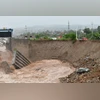
In Jammu & Kashmir, a large landslide near the
Vaishno Devi pilgrimage route on August 26 killed at least 31 people and injured dozens. Rescue teams continue to clear debris in the Katra area. Officials linked the slide to days of intense rain across the Union Territory. In a similar incident, several people were killed in the Kishtwar district a couple of weeks ago. The incident revived memories of the 2014 Jhelum floods that inundated Srinagar and displaced hundreds of thousands.
Meanwhile, in Uttarakhand, early-August cloudbursts and rain-triggered slides killed many people, left many more missing and forced evacuations from vulnerable valleys, according to district authorities quoted by Reuters. Operations in several Char Dham corridors were halted intermittently as debris blocked highways. The state knows the costs of cascading hazards, with the memory of the 2013 disaster that destroyed roads, bridges and homes still fresh.
In Himachal Pradesh, successive downpours through late August brought new slope failures, road closures, and house collapses. The total death toll for Himachal Pradesh's 2025 monsoon season has reached around 306, with landslides and saturated hillsides posing ongoing risks. Authorities have warned of further landslides as hillsides remain saturated and unstable. Schools have been closed and rescue operations are ongoing as critical infrastructure, including bridges and roads, has been severely damaged in the region.
In Punjab, flood-like conditions are currently being reported along the stretches of the Sutlej and Beas rivers after very heavy rain in their upper catchments. District administrations have moved people from low-lying villages and are monitoring releases from major reservoirs to manage downstream levels.
Yet meteorologists and disaster experts say the devastation is not simply about excess rainfall. A combination of fragile mountain geology, unplanned development, blocked drainage, encroachment, and weak infrastructure has amplified the toll.
What else is driving the destruction?
In Himachal Pradesh, geologists and risk agencies have long warned that steep hill-cutting for highways, inadequate slope stabilisation, and dumping of excavation “muck” onto riverbanks make monsoon damage worse. National guidelines on landslide risk flag precisely these practices and call for engineered slope protection, controlled muck disposal and drainage planning; when those measures lag, intense rain turns cuts and spoil piles into slide-prone scarps.
Meanwhile, audits and experts were pointing to silted channels, encroachments and the slow construction of the Jhelum flood-spill channel and dredging after the disastrous 2014 floods in Jammu and Kashmir. The deadly landslide that took place during this monsoon near Katra highlights a similar danger, but on slopes that are failures caused by rain and slow-crumbling mass wasting along busy roads with significant foot traffic.
The Himalaya’s young and fractured rock in Uttarakhand is prone to landslides. But rapid road widening along geologically sensitised alignments without uniform slope-stabilisation, using infrastructure already constrained by roots, becomes more susceptible to failures during cloudbursts.
An often-cited example is the Char Dham Highway project, with an outlay of ₹12,000 crore, and includes upgrading 890 km roads along with building bridges, flyovers, bypasses and culverts. A recent study reported that roughly 690 hectares of forest land has been cleared, over 55,000 trees have been cut down, and almost 20 million cubic metres of soil have been excavated, resulting in significant changes to slope stability and ecology in the region.
In the plains, the story shifts from slopes to channels. Heavy inflows from Himachal and Uttarakhand are swelling the Sutlej and Beas rivers, where floodplains are narrowed by embankments, encroachments or sand-mining scars. Due to this, rivers can rise faster and spread unpredictably. Districts then have to depend on reservoir operations, embankment integrity and local drainage capacity to keep water out of homes and fields.
What climate-resilient infrastructure exists in India?
The Union government’s National Landslide Risk Mitigation Project (NLRMP), run by the National Disaster Management Authority, gives funds for slope stabilisation, early-warning and capacity-building. As of mid-2024, the Centre said it had earmarked ₹1,000 crore under the scheme, with nearly ₹139 crore each sanctioned to Uttarakhand and Himachal Pradesh for risk-reduction works. The Ministry of Road Transport & Highways’ own Disaster Management Plan commits to “climate-resilient infrastructure, landslide mitigation and sustainable reconstruction practices” on national highways.
The World Bank’s Uttarakhand Resilient Infrastructure and Disaster Preparedness Project (U-PREPARE), approved in 2024-25 with a financing envelope of about $168.75 million, funds landslide mitigation, resilient bridges and improved emergency response. In Himachal Pradesh, the State Roads Transformation Project integrates climate-resilient design and slope-safety measures into priority corridors. These are material steps, but the coverage of these funds remains partial when compared to the length and network of the requirements.
The road ministry says it is mainstreaming disaster-risk reduction in highway planning, spending on road infrastructure has risen sharply over the past decade, and officials stress the need to make corridors safer and more sustainable. Speaking at Business Standard’s Infra Summit event on August 21, Union Transport Minister Nitin Gadkari stressed that artificial intelligence (AI) would soon be put to use to address challenges such as landslides and waterlogging in hilly areas. “Landslides in Himachal and Uttarakhand are a big challenge. We are trying to use AI to identify waterlogging and landslide spots and even monitor bridge strength,” he said.
The floods battering north India are a reminder that rain may be the spark, but the fragility lies in how we build and prepare. Climate-resilient infrastructure can no longer be a distant policy phrase.
(Note: Toll and displacement figures are evolving as state disaster management authorities update their tally)
 "North India's hill states are flooding again. Is rain the only culprit?")