2004 Indian Ocean tsunami set off work to be ready for the next big wave
That changed the day after Christmas in 2004, when a 9.1-magnitude earthquake west of the Indonesian island of Sumatra set off a mammoth wave that was recorded as high as 16 stories
 "Tonga tsunami, Tsonga tsunami")
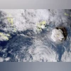
Tsunami experts have also worked to establish safety guidelines and emergency response systems for coastal communities facing risk.. | File Image: Japan Meteorology Agency via AP
Listen to This Article
By Katrina Miller
The Indian Ocean tsunami in 2004, one of the deadliest events in recorded history, was an enigma to many survivors. Some experts were surprised to learn that a significant number of the people in the path of those lethal waves had never heard of such a destructive phenomenon until it came their way.
“Tsunami is a Japanese word,” said Syamsidik, an engineer who now directs the Tsunami and Disaster Mitigation Research Center at Syiah Kuala University in Banda Aceh, Indonesia, and, like many Indonesians, uses only one name. At the time, he assumed that meant that only Japan needed to worry about the natural disaster. “It misled a lot of people. Including me.”
That changed the day after Christmas in 2004, when a 9.1-magnitude earthquake west of the Indonesian island of Sumatra set off a mammoth wave that was recorded as high as 16 stories, and in some places as fast as 300 miles per hour, as it raced toward the shorelines of South and Southeast Asia and East Africa.
Earthquake sensors hinted at the potential for destruction and death. But tsunami experts watching that data did not know who to tell. Their system showed no threats to coastal communities on either side of the Pacific Ocean, which at the time was the only region monitored for tsunami threats. There were few, if any, monitors, nor a model of what could occur, in the Indian Ocean.
Two decades later, scientists have made great strides in tsunami monitoring, modelling and forecasting. And organisations have bolstered education and preparedness, at both the local and global scales. Emergency preparedness planners are working to ensure that what happened in 2004 never happens again.
Also Read

 "Earthquake")
 "China building tsunami alert centre in South China Sea")
 "Tonga tsunami, Tsonga tsunami")
 "Japan Earthquake, Megaquake")
For all their work since the Indian Ocean event, other tsunamis have caused serious damage, including the disaster in 2011 in Japan, highlighting the difficulty of achieving a world with no tsunami deaths.
Most tsunamis are caused by earthquakes, but anything that displaces a large amount of ocean water, including landslides, volcanoes and meteor strikes, can trigger a big wave. According to the National Oceanic and Atmospheric Administration, 78 per cent of tsunamis between 1900 and 2015 occurred in the Pacific Ocean. Only 5 per cent originated in the Indian Ocean.
The tsunami on December 26, 2004, quickly escalated into a global disaster. Across 17 countries, nearly a quarter million people died and 1.7 million were displaced, mostly from Aceh, an Indonesian province on the northern tip of Sumatra. Property damage, amounting to $13 billion, left some towns unrecognisable.
Vasily Titov, a scientist at NOAA’s Pacific Marine Environmental Laboratory who simulates tsunamis, was shaken. “Theoretical knowledge is one thing,” he said. “Seeing what it was in real life is completely different.”
The 2004 wave, Titov said, revealed that the world’s tsunami warning system, started in 1965 to monitor threats in the Pacific Ocean, needed a critical upgrade.
The first step was to get better data. In 2000, six sensors were deployed in the Pacific to experiment with detecting tsunamis in the open sea, rather than when they reached the shore. NOAA began to expand this effort in 2005, and 10 other nations have followed suit, leading to the worldwide Deep-ocean Assessment and Reporting of Tsunamis, or DART, network.
Today, more than 70 DART sensors measure water temperature and pressure in places that are considered tsunami zones. NOAA also operates coastal water stations and satellites to monitor ocean height, roughness and tides.
That information is transmitted to warning centres that, in addition to the Pacific, now cover the Indian Ocean, the Caribbean, the northeastern Atlantic Ocean, and the Mediterranean Sea. The data gets input into forecasting models that have been updated to better predict tsunami activity from earthquakes and nonseismic sources. In the past two decades, forecasters have gone from not being able to predict the height of a wave to giving a “pretty good” estimate up to half an hour before it hits, said Laura Kong, director of the International Tsunami Information Center, which is hosted by the National Weather Service in Hawaii.
Tsunami experts have also worked to establish safety guidelines and emergency response systems for coastal communities facing risk.
But there is still work to do. Global early warning systems are either fast or accurate, but struggle to achieve both, said Ardito Kodijat, head of the Indian Ocean Tsunami Information Center at UNESCO.
©2024 The New York Times News Service
More From This Section
 "Bashar Al-Assad, Syrian President, Assad")
 "Russian Foreign Minister Sergei Lavrov speaks at a press conference, during the G20 summit, in New Delhi, Photo: Reuters")
 "Azerbaijan")
 "Brahmaputra, Brahmaputra river")
 "Houthis Yemen")
Topics : Tsunami Natural Disasters Indian Ocean
Don't miss the most important news and views of the day. Get them on our Telegram channel
First Published: Dec 27 2024 | 12:14 AM IST