Heavy rainfall hits multiple regions in Kerala, IMD issues orange alert
Heavy rainfall over multiple regions in Kerala led to waterlogging, disrupted road traffic, and widespread inconvenience
 "Rain, Chennai Rains")
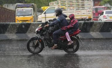
India Meteorological Department (IMD) has issued an orange alert, predicting heavy rains, in Kerala, representative image (Photo: PTI)
Listen to This Article
Heavy rainfall hit multiple regions across Kerala on Friday, leading to waterlogging, disruption on road traffic and widespread inconvenience. The India Meteorological Department (IMD) issued an ‘orange’ alert in five districts and warned of thunderstorms in parts of the state. Meanwhile, Cyclone Dana made landfall in Odisha, weakening after impacting eastern coastal regions.
What is IMD’s ‘orange’ alert?
The Indian Met department uses a colour-coded alert system to indicate the severity of weather conditions, especially during extreme events like heavy rainfall. An ‘orange’ alert means that people should ‘be prepared’ for potentially severe weather. This could entail rainfall between 64.5 mm and 204.4 mm in a day. The alert also often indicates a likelihood of widespread rainfall with high intensity over a particular region.
People living in affected areas are advised to be cautious, avoid unnecessary travel, and follow the instructions provided by local authorities. The IMD might also recommend securing outdoor items and preparing for possible waterlogging or localised flooding.
An orange alert typically implies a moderate to high risk of disruption to daily life, with potential impacts on transportation, electricity, and communication networks.
Kerala braces for heavy rainfall
In Kerala, the IMD issued an orange alert for the districts of Thiruvananthapuram, Kottayam, Ernakulam, Idukki, and Thrissur. The heavy rains can lead to flash floods, landslides, and hazardous conditions. A yellow alert, signalling heavy rainfall between 6 and 11 cm, is also in place for seven other districts in the state.
Also Read

 "MD Director General Mrutyunjay Mohapatra")
 "Rain, Chennai Rains")
 "Cyclone Remal")
 "Cyclone Dana")
 "Rain, Bengaluru Rains, Spawn cyclone, Karnataka Rains")
According to the IMD forecast, Thiruvananthapuram and Kollam are expected to experience thunderstorms with intense rainfall and gusty winds. Additional warnings predict moderate rainfall with gusty winds in parts of Pathanamthitta and Alappuzha.
Cyclone Dana weakens post-landfall in Odisha
Meanwhile, Cyclone Dana, which began its landfall between Bhitarkanika in Kendrapara district and Dhamra in Bhadrak district on Thursday night, has weakened into a cyclonic storm. The system was initially categorised as a severe cyclonic storm, with wind speeds reaching 110 kmph as it moved north-northwest at a speed of 15 kmph. The storm’s impact extended to Odisha, West Bengal, and other eastern coastal regions.
Chief Minister of Odisha Mohan Charan Majhi reported that Prime Minister Narendra Modi and Union Home Minister Amit Shah were briefed on the state’s storm preparedness ahead of the cyclone’s landfall. Meanwhile, the Congress party has urged the central government to provide comprehensive support to the affected states, recommending full deployment of emergency response measures to ensure public safety.
As the storm weakened, the cyclone was positioned approximately 50 km north-northwest of Dhamra and 30 km northeast of Bhadrak. IMD officials stated that Cyclone Dana is expected to move northwest across northern Odisha, weakening further into a deep depression within the next six hours. The system remains under close monitoring by the Doppler weather radar stationed at Paradip. The system is tracking its trajectory and intensity in real-time.
[With agency inputs]
More From This Section
 "India china, India, China")
 "Farooq Abdullah, Farooq, Abdullah")
 "Cyclone Dana, Cyclone, Dana")
 "PM Modi")
 "Sachin Waze")
Topics : IMD IMD on rains Kerela heavy rains BS Web Reports
Don't miss the most important news and views of the day. Get them on our Telegram channel
First Published: Oct 25 2024 | 2:28 PM IST