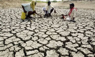
India braces for driest August since 1901 amid intensifying El Nino
India recorded a rainfall deficit of 25 per cent in August 2005, 24.6 per cent in 1965; 24.4 per cent in 1920; 24.1 per cent in 2009 and 24 per cent deficit in 1913, according to the IMD data
)
Listen to This Article
India is poised to experience the driest August since 1901 which, senior meteorologists say, is a clear result of intensifying El Nino conditions.
Also, the monsoon this year may end up being the driest since 2015, which recorded a rainfall deficit of 13 per cent, they said.
With a 32 per cent precipitation deficit in August so far and the prediction of only subdued rainfall activity over a large part of the country in the next three days, India is on track to record the driest August since 1901, an India Meteorological Department (IMD) official said, requesting anonymity.
August receives 254.9 mm of rainfall, accounting for around 30 per cent of the precipitation during the monsoon season.
India recorded a rainfall deficit of 25 per cent in August 2005, 24.6 per cent in 1965; 24.4 per cent in 1920; 24.1 per cent in 2009 and 24 per cent deficit in 1913, according to the IMD data.
Also Read
IMD chief Mrutyunjay Mohapatra said the primary reason for below-normal rainfall in August was El Nino -- the warming of waters in the Pacific Ocean near South America -- besides the "unfavourable phase of the Madden Julian Oscillation (MJO) which is known to reduce convection in the Bay of Bengal and the Arabian Sea".
El Nino is generally associated with the weakening monsoon winds and dry weather in India.
The MJO is a large-scale intraseasonal atmospheric disturbance originating in tropical Africa and travelling eastwards. It is like a pulse or wave lasting about 30 to 60 days.
During the active phase of the MJO, the atmosphere becomes more favourable for rainfall. This leads to increased cloud cover, stronger winds, and enhanced convective activity, resulting in heavier rainfall over the Indian subcontinent.
"The favourable phase of MJO results in rainfall even if there is no low-pressure system. July recorded above-normal rainfall due to the favourable phase of MJO," Mohapatra said.
Only two low-pressure systems developed over the Bay of Bengal (BoB) against a normal of five under the impact of the prevailing El Nino conditions, he said.
"Another reason for below-normal rainfall in August was a lower number of low-pressure systems in the South China Sea and they, too, moved northward," he said.
Low-pressure systems that develop over the South China Sea typically move westward, reaching the north BoB after crossing Vietnam and Thailand.
Owing to the positive Indian Ocean Dipole (IOD), the outlook for September is not very bleak, Madhavan Rajeevan, former secretary at the Ministry of Earth Sciences, told PTI.
"September is not expected to be as bad as August. Models suggest the September rainfall will be on the lower side of the normal," he said.
The senior meteorologist said El Nino is the primary reason for the high rainfall deficit in August.
"The absence of the positive phase of MJO must have also played a marginal role," he said.
At a press conference on August 1, the IMD had said El Nino and other unfavourable conditions may suppress rain in August, though cumulative precipitation in the second half of the monsoon season (August-September) is expected to be normal.
"Rainfall in September is likely to be on the lower side (94 per cent to 99 per cent) of the normal (422.8 mm)," Mohapatra had said.
Rainfall recorded between 94 per cent and 106 per cent of the long-period average (LPA), or 50-year average, is considered normal.
Normal rainfall is critical for India's agricultural landscape, with 52 per cent of the net cultivated area relying on it. Additionally, it plays a crucial role in replenishing reservoirs essential for drinking water and power generation throughout the country.
Rainfed agriculture contributes to approximately 40 per cent of the country's total food production, making it a vital contributor to India's food security and economic stability.
(Only the headline and picture of this report may have been reworked by the Business Standard staff; the rest of the content is auto-generated from a syndicated feed.)
More From This Section
Don't miss the most important news and views of the day. Get them on our Telegram channel
First Published: Aug 29 2023 | 8:19 PM IST


